Showing posts with label planning. Show all posts

Thursday, July 28, 2016

Mapping local knowledge to drive sustainable natural resource management, influence policy-making and promote climate change adaptation

A new publication from the Technical Centre for Agricultural and Rural Cooperation (CTA) illustrates how local communities in a range of developing countries have developed a bird’s-eye perspective of their land and water resources through Participatory 3D modelling (P3DM). This innovative technique is proving a valuable tool for often voiceless groups, helping them to manage and protect their habitats, influence decision-making and take control of their future.

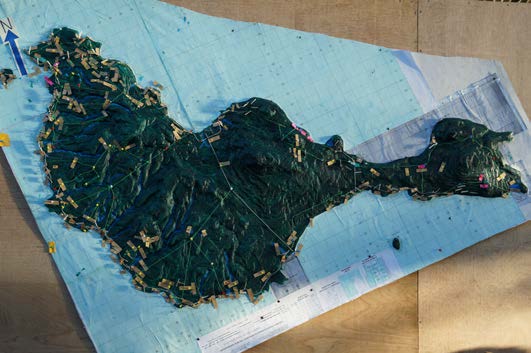
Improving natural resource management, mapping community rights and bolstering climate change adaptation – participatory 3D modelling can help to do all this and more. Developed in the early 1990s in Southeast Asia, the technique offers communities a tangible way of visualising tacit knowledge, producing stand-alone relief models that depict natural surroundings, but also cultural information, helping groups to assert their rights and protect their traditional knowledge from outside exploitation.

CTA has been in the forefront of P3DM development in African, Caribbean and Pacific countries, launching it in Fiji, Gabon, Kenya and Trinidad and Tobago, and helping to foster South-South cooperation to spread the practice further afield. The Power of Maps: Bringing the Third Dimension to the Negotiation Table documents some of the achievements obtained so far. All twelve of the case studies presented show how the process of building 3D maps has led to positive changes.

“Traditional knowledge is gaining recognition at the international level, but at the local level, government officials and technocrats tend to dismiss it as anecdotal and scientifically unproven,” said CTA P3DM expert and Senior Programme Coordinator ICT Giacomo Rambaldi. “The process documented in this book enables knowledge holders to visualise and georeference their traditional knowledge and to engage outsiders in a peer-to-peer dialogue.

Building a P3DM model generally involves the entire community, with the elders supplying their traditional knowledge and children taking charge of the actual construction, using cardboard, paints, pushpins and yarn. An important part of the exercise is the way it brings generations together, giving value to the contributions of each and making people feel a sense of pride – in their surroundings and heritage and in the map itself.

On the Pacific island of Ovalau, a P3DM initiative led farmers and fishers to adopt more sustainable land use and fisheries practices, with significant increases in production as a result. Impacts included a doubling of fish stocks, a sizeable increase in crop output and a rise in the number of tourists visiting the island. In Madagascar, the creation of a 3D map drew an initially sceptical community into a watershed planning process, with people quickly seeing the benefits in terms of improved resource management and income generation.

Members of a pygmy community displaced to make way for a protected area in the Democratic Republic of Congo used the web of knowledge displayed on their 3D map to regain access to traditional lands and claim a role in managing them. Meanwhile, in Kenya, a three-dimensional mapping exercise helped the Ogiek tribe to document its ancestral land rights and knowledge systems, with far-reaching repercussions – including shaping government policy on indigenous peoples.

Climate change poses a special threat to vulnerable small island states, and on the Caribbean island of Tobago, P3DM has been used to guide community driven disaster risk reduction strategies. In another three-dimensional mapping exercise in the region, the experience of building a climate risk map of Grenada has produced the added spin-off of strengthening the capacity and professional networks of local organisations. One unexpected outcome has been the signing of an international partnership to fund the replanting of mangroves, as part of an ecosystem management strategy to protect the island from persistent hurricanes that are endangering lives and livelihoods.

Further information:

Watch The enabling power of participatory 3D mapping among the Saramaccan Peoples of Suriname (part 1 & 2):
Visit CTA’s PGIS website
Read about the life-changing effect of P3DM
Known locations of P3DM exercises in Africa, the Caribbean and the Pacific
Collection of case studies: www.iapad.org

P3DM on social media:

www.facebook.com/ppgis
www.twitter.com/ppgis
www.vimeo.com/channels/pgis
www.ppgis.net

Order or download the publication (at no cost - eligibility criteria apply):

English version

Wednesday, January 06, 2016

The Right to be Different: Struggle for Water and Identity in the Andes


In the parish of Licto, near Riobamba, in Ecuador, the indigenous population fought for its water. Indian peasants participated in the design, construction and organisation of the irrigation system. After more than 20 years the water finally reached the community. The story is told by InĂ©s Chapi, an Indian woman, who came a long way from being oppressed and discriminated against to become a most respected irrigation organiser in the system.  In the Andes they call it blood of the earth, the source of life from which other life grows. Water, feeding the land as well as the imagination. Giving rise to rituals and myths, fueling tradition and culture. Ancient and modern conquerors of these highlands denied the indigenous people access to springs and rivers. Water became a source of conflict. And usually the Indians got a raw deal.

Based on: The Rules of the Game and the Game of the Rules’ by Rutgerd Boelens; Executive producer and scenario: Barend Hazeleger; Photography: Thom Deelstra; Sound recordist: Juio Gorck; Editing: Jan Pieter Tuinstra & Barend Hazeleger; Scientific research and Interviews: Rutgerd Boelens; Produced by Agrapen and Wageningen University (2003)

More on the case: http://bit.ly/1OAlBsX

Sunday, December 22, 2013

Involving communities in project planning using Participatory 3D modelling (P3DM): the experience of Epi Island, Vanuatu

Senior students of Epi High School felt privileged when they were chosen to construct the model of Epi island using a modeling technique known as Participatory 3 Dimension Modelling (P3DM), as part of a key community consultation process by the Pacific Adaptation to Climate Change (PACC) project on the island of Epi. With the help of students, each community members were able to use tagging pins and colored paper strips to label current physical features on the island as well as map out future developments recommended by each area councils.

Land boundary is a critical challenge in Vanuatu. On Epi alone, such project implementation requires acquisition of land prior to any physical work being carried out. The use of Participatory 3-D modeling gave land owners and area council representative a physical overview of the roading issues. After recognizing the problems and the proposed solutions under the PACC Vanuatu project, the land owners and area council representatives agreed to give ' for free' their land and resources for PACC project implementation on Epi. Under the PACC project where the thematic area is Coastal Infrastructure, the road relocation project is aimed at building resilience and improving access for the people to the main service and commercial center on the island.

The current 72km road from South through West to the North of Epi is located along the coast. A physical feature evident along this road is the continuous erosion of the road due to either heavy downpour resulting in landslides along road sides, , running water drenching the road surface making it difficult to travel on, and ocean waves impact on the road sides, washing away the roads.

Following the successful outcome of the Participatory 3-D model consultation, the PACC team selected VARSU area to commence the road relocation project.The VARSU area council on North Epi is the first community to physically map out a new 10 km road in the interior of the island, with the objective of having climate proof roads that will not be washed away at the coast, and to have better and safe access to markets.

Source

Monday, June 04, 2012

Handbook on Participatory Land Use Planning Methods and tools developed and tested in Viengkham District, Luang Prabang Province, Lao PDR


This approach puts the keys of development in the hands of local communities and avoids engaging them into endless assistance programs”; District Governor - Viengkham - 2011

Securing land tenure rights for village communities through participatory land use planning is a hot topic for policy makers, researchers and development practitioners. In Lao PDR, the government policy aimed at turning land into capital may well turn to land grabbing wherever local communities are not informed about their rights and are not involved in land use planning. PLUP is an empowerment process for villagers who get trained as land use negotiators. They learn the real value of their land and labor. The proposed PLUP method helps them to visualize land related issues, to assess the potential impact of alternative scenarios before they make decision.

While local people know well their own situation they often do not know how to collectively design a better future for the whole village through land use planning. ‘PLUP fiction’ is a learning device for land zoning and local development planning. Based on a virtual village territory visualized on a board, members of the village land management committee learn how to make informed decisions about land zoning according to the needs of different stakeholders. Using the method learned during the landscape simulation game, they negotiate their own land use zoning on the 3D model representing their village landscape. They first design their current land use by using colored pins and string on the 3D model. Then, land zones are digitized, analyzed and compared to the needs expressed by the villagers in their village action plan, i.e. village economic development, labor force availability, rice sufficiency, livestock carrying capacity, preservation of ecosystems services.

New land use plans are designed successively until all the committee members are satisfied. The iterative zoning process is facilitated by the use of a GIS software (QGIS) and an Excel based tool. On completion of the PLUP exercise, the 3D model painted with the new land use plan remains with the community.

The purpose of this PLUP Handbook is to provide practical tools and methods for PLUP implementation based on experiments conducted in Viengkham District, Luang Prabang Province. Lessons drawn from this experience have been gradually incorporated into the tools and procedures described in this Handbook and Toolbox as a reference guide for PLUP practitioners.


Publisher: National Agriculture and Forestry Research Institute (NAFRI), Institute of Research for Development (IRD) and Centre for International Forestry Research (CIFOR), May 2012

A short history of the method development

At the end of 2009, a manual for Participatory Land Use Planning (PLUP) was published by the Ministry of Agriculture and Forestry (MAF) and the National Land Management Authority (NLMA) to provide a common basis for PLUP implementation in Lao PDR. This manual determined the important principles of PLUP implementation, especially in relation to community participation in the process. A diagnostic study conducted a few months later in a project implementing PLUP along the new guidelines showed that on-the-ground PLUP implementation was still problematic as some tools and methods had not been detailed in the PLUP Manual.

In 2010, participatory action-research conducted by the National Agriculture and Forestry Research Institute (NAFRI, Laos) together with relevant district line agencies (District Land Management Authority (DLMA) and the District Agriculture and Forestry Offices (DAFO) with the support of the Institute of Research for Development (IRD, France) and the Centre for International Forestry Research (CIFOR, Indonesia) led to an innovative PLUP method adapted to the local situation in Viengkham District, with landscapes dominated by subsistence-based shifting agriculture. The main challenge was to insure participation of the villagers and their full understanding of the planning process.

In 2011, through partnership with Agrisud project on food security and rural development the participatory approach was further improved, adding village monograph and Village Action Plan (VAP) as to prepare follow-up extension activities.

Download the handbook.

Monday, September 05, 2011

The Manus MOSAIC - Participatory 3D modeling for climate change adaptation across Manus Province, Papua New Guinea

At the Manus Province Climate Change Seminar ‘Manus Way Forward’, October 2010, over 70 participants presented and shared experiences, expertise and ideas on how to adapt to climate change impacts. As part of the recommendations, representatives from the Provincial Government suggested using Participatory 3D modeling (P3DM) as a tool to help convene stakeholders and discuss province-wide responses to climate change impacts that would support and build on local efforts and scale-up impacts and opportunities.

In particular, the tool was proposed as a way to initiate discussion on a protected area network for Manus, the Manus ‘MOSAIC’. The exercise would be an initial step in outlining the spatial coverage of key ecosystem services, such as watersheds, reefs and mangroves, and representing and discussing opportunities for strengthened management of these areas under a future of climate change, and in the context of social and economic development for the province. The opportunity to involve local stakeholders from all LLG jurisdictions in this process will help develop a roadmap for the development of a Manus ‘MOSAIC’ protected area network.

Participatory 3D modelling

Participatory 3D modelling (P3DM) is a fully collaborative exercise that combines community mapping with open discussions on land-use and land-use planning scenarios.  It combines geographic precision with local, individual spatial knowledge and ‘mind-maps’ of locality and familiar settings.  During a P3DM exercise, all participants contribute to make a physical, hands-on wood-and paper model, to scale, of their community, island or area. This is typically made on a large table in the centre of a meeting hall, school or other public place. Once the model is made, then people become ‘resource persons’ and informants, and everyone will contribute to placing features and places onto the model. Key informants, such as elders and experienced fishermen or foresters, will offer their view of past events, of boundaries, of key localities and times for certain activities, and these can be discussed, and learned, by all participants.

Below is the video produced during the Solomon Islands event in February 2011.


In this way, the model is more than just a map, it is a representation of spatial knowledge of the participants, and a source of discussion and interpretation around key issues.

Proposed area of Manus to be represented by the P3DM exercise (Map by Nate Peterson, TNC)
Although one key objective of this exercise is to plan for protection and restoration of key natural features, and to plan for possible climatic changes, other issues that are important to the province and the participating communities can be discussed in the same context. Furthermore, the model and the information can be used again, and again, for collaborative discussions and planning on key development issues. Digital GIS can be extracted from the model, and vice-versa, to aid and inform future discussions.  In this way, scientific information can be easily communicated and integrated with local knowledge and understanding.

Activity overview

The P3DM exercise will take place over a two-week period, from Monday 29th August to Friday 9th September. The first week will be dedicated to constructing the blank relief model, working closely with the local high-schools schools in Lorengau to allow students the opportunity to have a hands-on lesson in geography. It will also allow those participants interested in training / learning how to carry out a P3DM the opportunity to get involved.

The second week will concentrate on making the blank model come alive. Participants from all areas of Manus, and with all technical and local backgrounds, will discuss and add information to the model, including point data (features such as houses, schools, waterfalls, caves etc), line data (roads, streams, rivers, tracks, paths, boundaries, fences, cables, runways etc) and area data (polygons, such as mangroves, forest concession areas, reef flats, beaches, airports etc). Local knowledge on boundaries and features from participants from each part of Manus will contribute to an overall local picture of the province. Official and technical data can also be cross-referenced with local understanding, and represented on the model.

Towards the end of the second week, a facilitated discussion will focus on key issues, including ecosystem services and existing and proposed protected areas; current and proposed development activities (mining, forest concessions, urban and commercial expansion); and information related to predicted climate change impacts.

Future discussions on the proposed Manus MOSAIC protected area network can build on this initial analysis and use the 3D model for further participatory mapping.

General objectives of the Manus MOSAIC P3DM:

The P3DM exercise will enable all participants:
  • To learn and understand Geographic Information Systems (GIS) in an open, hands-on and accessible way
  • To participate in spatial planning for their own area as well as for the whole province
  • To identify planned developments and trends in land-use change, and assessing the impacts of these changes on key ecosystem services
  • To open a discussion on climate change impacts and how to integrate adaptation into spatial planning at local and provincial scales
  • To discuss management and protection measures for key ecosystem services in the context of scaling-up beyond local efforts to ensure the best network of connectivity in conservation and adaptation efforts for the whole province
Author: James Hardcastle, The Nature Conservancy
Source: Eldis Communities | blog

Thursday, June 02, 2011

CCE Talks: Community-Based Mapping Tools - Nina-Marie Lister


Nina-Marie Lister is an Associate Professor of Urban and Regional Planning at Ryerson University and Visiting Associate Professor at Harvard University Graduate School of Design. She presents on mapping projects that relate landscape, ecology and urbanism and enable communities to decide what is mapped, for whom and for what purpose.

Presented by the Centre for City Ecology

May 18th, 2011

Urbanspace Gallery, Toronto

Thursday, July 29, 2010

Recreando nuestra Cultura, Mapeando nuestro Futuro


El cuento de un encuentro especial en Venda, Sur Africa, y un proceso comunitario de cartografĂ­a eco-cultural. LĂ­deres indĂ­genas del Altai (Rusia) y la AmazonĂ­a Colombiana, juntos con representantes de ONGs de Sur Africa, Kenia y EtiopĂ­a, acompañan a la comunidad de Tshidvizhe mientras que descubren una sencilla pero poderosa manera de expresar el pasado y el presente de su territorio  en mapas hechos a mano. Los mapas destacan la importancia de su cultura, los sitios sagrados, el territorio y sus modos de vida, y empoderan a la comunidad mapear el futuro por lo cual deben luchar.

Wednesday, September 30, 2009

The Touch Table for participatory land use planning

This video shows how the Touch Table can be used to support land use planning with multiple stakeholders with multiple interests