
Senior students of Epi High School felt privileged when they were chosen to construct the model of Epi island using a modeling technique known as Participatory 3 Dimension Modelling (P3DM), as part of a key community consultation process by the Pacific Adaptation to Climate Change (PACC) project on the island of Epi. With the help of students, each community members were able to use tagging pins and colored paper strips to label current physical features on the island as well as map out future developments recommended by each area councils.
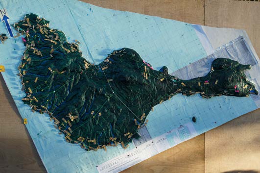 Land boundary is a critical challenge in Vanuatu. On Epi alone, such project implementation requires acquisition of land prior to any physical work being carried out. The use of Participatory 3-D modeling gave land owners and area council representative a physical overview of the roading issues. After recognizing the problems and the proposed solutions under the PACC Vanuatu project, the land owners and area council representatives agreed to give ' for free' their land and resources for PACC project implementation on Epi. Under the PACC project where the thematic area is Coastal Infrastructure, the road relocation project is aimed at building resilience and improving access for the people to the main service and commercial center on the island.
The current 72km road from South through West to the North of Epi is located along the coast. A physical feature evident along this road is the continuous erosion of the road due to either heavy downpour resulting in landslides along road sides, , running water drenching the road surface making it difficult to travel on, and ocean waves impact on the road sides, washing away the roads.
Following the successful outcome of the Participatory 3-D model consultation, the PACC team selected VARSU area to commence the road relocation project.The VARSU area council on North Epi is the first community to physically map out a new 10 km road in the interior of the island, with the objective of having climate proof roads that will not be washed away at the coast, and to have better and safe access to markets.
Source